Drone Survey of Remote Landslide (Public Authority Project)
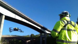
When terrain is hazardous and access is impossible, conventional site surveying becomes risky or impractical. This is where Drone Surveys become an invaluable and safer alternative for crucial safety inspection work.
Our Drone Survey team were commissioned by a local public authority to carry out a drone survey over a remote landslide-affected slope. Our mission: to collect high-resolution aerial imagery, terrain models, and risk data without exposing survey teams to danger. This project showcases how aerial inspection, geotechnical mapping, and drone-based remote sensing can transform infrastructure risk assessment.
Unstable Ground and Restricted Access
Following reports of a landslide in a remote area, local authorities needed an urgent assessment of the affected slope and its potential impact on nearby infrastructure. However, the site presented serious challenges:
-
Unstable ground conditions made foot access unsafe for survey teams.
-
Steep gradients and loose debris increased the risk of further slippage.
-
Limited road access prevented the use of heavy survey equipment.
The client required high-quality, accurate visual data to assess the risk zones, determine the extent of the landslide, and plan remedial works — but without exposing personnel to unnecessary danger.
Balmore was tasked with delivering a comprehensive aerial survey that could map the affected area quickly, safely, and in detail.
Our Approach
Aerial Data Without Compromise
Our commercial drone survey fleet is built for precision and reliability in even the harshest environments. For this project, we deployed a drone equipped with a high-resolution optical camera and advanced mapping sensors capable of capturing fine topographic detail from a safe distance.
Our drone operations team began by conducting a full pre-flight risk assessment, taking into account terrain conditions, airspace restrictions, and environmental considerations. We then established flight paths that maximised coverage while maintaining safe operating altitudes above unstable areas.
This aerial survey allowed us to:
-
Capture detailed imagery of the landslide and surrounding slope.
-
Generate accurate elevation data to identify run-out zones.
-
Map the extent of debris movement and its proximity to key assets below.
-
Provide rapid insights to engineers and planners for immediate decision-making.
By eliminating the need for manual access, our drone operations ensured zero risk to personnel while delivering the detailed information required for structural and environmental analysis.
Precision Data for Informed Decisions
Within hours of completing the survey, our team processed the aerial data into high-resolution orthomosaic imagery and 3D terrain models. These outputs offered an unprecedented view of the site, enabling the client’s engineers to visualise slope instability and assess ongoing risk to nearby roads and utilities.
Key deliverables included:
-
High-definition imagery for visual assessment of affected zones.
-
Accurate digital elevation models (DEMs) for slope analysis.
-
Annotated maps highlighting risk areas and potential run-out paths.
-
Secure digital reporting for integration into the authority’s GIS systems.
This combination of speed, accuracy, and safety allowed the public authority to make informed decisions about emergency measures, slope stabilisation, and long-term monitoring — all without the delay or danger of traditional ground surveys.
Safe, Fast, and Highly Detailed
Our drone survey services provided the client with the crucial data they needed, faster and safer than any manual alternative.
The outcome:
-
Zero personnel risk: No need for surveyors to enter hazardous terrain.
-
Rapid data turnaround: Complete site capture and reporting within 24 hours.
-
Exceptional image clarity: Detailed visuals for structural and environmental assessment.
-
Operational efficiency: Minimal disruption, no road closures, and reduced costs compared to traditional methods.
Our aerial mapping gave the engineers a full understanding of slope movement and potential secondary risks to nearby infrastructure — enabling evidence-based planning and immediate safety action.
Leaders in Drone Surveying and Inspection
Balmore has become one of Scotland’s most trusted names in drone surveying, inspection, and aerial mapping. From landslides and cliffs to industrial roofs and bridges, our drone services delivers accurate, real-time data that helps clients manage risk, plan maintenance, and make faster decisions.
Our drone services are backed by a multi-disciplinary team that includes:
-
CAA-approved drone pilots
-
Engineering and structural specialists
-
Data analysts and mapping experts
-
Rope access and confined space teams for integrated solutions
Whether for remote terrain surveys, critical infrastructure inspections, or environmental monitoring, we provide a full-service solution — from flight planning to data delivery.


Quotes & Enquiries
At Balmore, we offer the expertise of four decades in difficult access works including roofing, rope access, industrial cleaning and drone inspection services. Our one stop shop approach to inspection, repair and cleaning has grown through our desire to constantly exceed our clients expectations and offer a service that is far superior to our competitors.
Please fill in the form outlining your requirements and our contract team will be able to provide you with a bespoke quotation for your inspection, repair or cleaning needs.